It’s as easy as A, B, Sea: B for Baffin Bay

Locator for Baffin Bay.

Image via Wikipedia

I love the game Scattegories so I am going to be drawn to learning new words that will help me gain more points.

The Baffin Bay separates Greenland from Canada and is connected to the Atlantic Ocean by the Davis Strait. You won’t be finding any vacation homes along the shores of the Baffin Bay as the surrounding islands are cold and mountainous and the Bay is covered in ice for most of the year.

The Baffin Bay is approximately 700 miles long, varies from 70 to 400 miles in width and ranges from 1,200 to 9,000 feet deep.

Ringing in the New Year with Carnival of the Blue

Here it is January and we’ve all sang our last rendition of ‘Auld Lang Syne’. Conversely, what this Beach Chair Scientist has to say is that these marine science bloggers should not be forgotten!

As the host for the Carnival of the Blue No. 44, I proudly bring to you these powerful, poetic, funny, insightful and delightful posts from the last month of 2010. Enjoy!

On December 15, the Wanderin’ Weeta of British Columbia took the time to put together a post about how plastic bags are often a deadly enemy of seabirds. She states that, “Researchers estimate that around 95% of all seabirds have eaten plastic litter.” Please see her post to watch a very eye opening video from YouTube.

The always humorous Mad Kane of New York wrote a light and lovely haiku septet on December 21 about the rare total eclipse during the winter solstice. Enjoy this post and be reminded of the rhythm of the verse!

Also, on December 21 Ben Goldfarb of FishiLeaks shared a post of how Moray eels do the darnedest things! Read his post to learn about the unusual behaviors of these fish.

Next, the NeuroDojo of Texas introduced us to the Dinochelus on December 28. Check out this post for a look at this lobster-like crustacean with an extraordinary claw which we just aren’t sure what it is used for yet.

Last but not least, Miriam of the Deep Sea News rounded out the year on December 29 with a wonderful post on the trials and tribulations of being a compassionate and responsible seafood eater. Read this post if eating sustainable seafood is a part of your New Year’s resolution.

Enjoy and have a wonderful 2011!

Beach Chair Scientist’s Top Ten Posts

Now that we have posted 200 entertaining posts of random beach trivia we thought it would be fun to review the most visited posts to see what our audience enjoys reading from us. So during this holiday season let’s make a toast to the top ten most read entries.

Thanks for reading all the posts from BCS and let us know if you have a questions while digging your toes in the sand!

What about blob (fish)?

The First Beach Chair Scientist post is about my favorite animal – The Atlantic Horseshoe Crab

Break it down. It’s hammertime … (doooo doo doo dut .. doo dut ..doo dut.)

10 facts about manatees

What do you mako this?

How much salt is in the ocean?

What eats sea urchins?

Do lobsters mate for life?

Swiped bass

Who is afraid of Atlantic wolf (fish)?

Carnival of the Blue #44 – December 30 deadline

Hey there! We have some very exciting updates for you today.

First of all, I want to say that November was a slow month for posts since I was busy taking care of a little newborn. The next generation of Beach Chair Scientist was born November 3. All are happy and healthy.

Secondly, can you believe this is our 200th post? Since we began July 13, 2008 there have been quite a slew of interesting posts. I will post the top posts later this week.

Lastly, I am collecting entries for a Carnival of the Blue post for January. Send me your best December posts by December 30th.

Have a great holiday season!

Who discovered the North Pole?

From the summer to the winter the amount of ice in the Arctic Ocean doubles from 3 million square miles to 6 million square miles. The smallest of all the oceans was explored by those looking for trade routes between the Atlantic and Pacific Oceans. But, the first to reach the North Pole was American Robert Peary in 1909 on dog sleds.

Nowadays travelers searching the Arctic Ocean need ships with powerful bows and engines needed to penetrate the sea ice.

A naturalist’s must-see destination: Chesapeake Bay

Map of the Chesapeake Bay Watershed

Image via Wikipedia

This is a continuation on the “Where we live” series. The Chesapeake Bay has undergone similar changes to the San Francisco Bay as the population increased along its shores. As the largest estuary in North America (not the longest, which is the Indian River Lagoon in Florida), it is not surprising that the watershed of the Chesapeake Bay flows through six states and covers an area of 64,000 square miles. Flowing from the watershed and into the Bay are over 124,000 miles of rivers and streams!

Due to the relatively shallow average depth of the Bay (at nearly 21 feet) the sun can reach the bottom easily and makes for a productive ecosystem. Just about 40% of the nation’s blue crab commercial blue crab harvest comes from the Chesapeake Bay. Nearly, 300 hundred species call the Bay their home during some part of their life cycle. Birds have come to rely on the diverse community for sustenance while making their way along the Atlantic Flyway.

As I mentioned above, the Bay has undergone changes in recent history. These changes have been rather unfavorable as more and more people flock to the the shores of the Bay, disturbing the natural balance.  The Chesapeake Bay Program is an organization leading the way it the restoration efforts and is often seen as the model on how to mitigate the effects of man and maintain a healthy existence of man and nature.

A naturalist’s must-see destination: San Francisco Bay

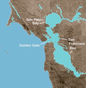
San Francisco Bay © 2004 Matthew Trump

Image via Wikipedia

I thought it might be interesting to take some time each week over the next few months to get to know a particular body of water in different regions of the world. For today I am starting off with the San Francisco Bay.

The San Francisco Bay is an extraordinary place that has undergone changes just as big as the state of California itself. The Bay is rather shallow at an average of 18 feet deep. Surprisingly, the watershed for the Bay is just about 40% of the state of California!

San Francisco Bay, Suisan Bay, San Pablo Bay and the Sacramento-Joaquin Delta are the connected inlets that we call the San Francisco Bay waterway, a true urban estuary, with the freshwater coming from the Sacramento and San Joaquin rivers. I think this Bay is particularly interesting since it is a tectonic estuary and has been formed by the movement of the San Andreas fault.

Over recent years (since the time of the Gold Rush when humans really began to alter the landscape of the Bay), the Bay has seen a reduction in over 85% of its marshland. With the diversion of freshwater from north of the Bay (where most of the state’s freshwater is located) to below the Bay (where most of the state’s people are located) the Bay has seen a balance shift affecting many of its natural systems. For more information about how to Save the Bay visit the Save the Bay San Francisco. They have been working to restore the balance of humans and nature in the Bay since 1961.

Who owns the oceans?

We all own the oceans … no, wait! No one owns the oceans. Sometimes it is very confusing to answer this question.

Since the third United Nations Convention on the Law of the Sea the jurisdictions of the oceans are known as this:

  • 0-3 nautical miles from the coastline of the country is considered a countries’ territorial seas and are subject to the rules of the country. Invading these waters can be seen as attack.
  • In the United States 0-12 nautical miles is subject to individual state laws.
  • Adjacent to the 12 nautical miles and out to 200 nautical miles is the Exclusive Economic Zone which gives states and/or a countries the “right to explore and exploit, and the responsibility to conserve and manage, the living and non-living resources.”

For more information click here.

What is bioluminescence?

Bioluminescence means light (as in ‘illuminate‘) from life (prefix ‘bio‘).

It is produced by a chemical reaction in many marine or terrestrial organisms. The reaction begins with a chemical called luciferase that catalyzes another chemical, luciferin, to then make oxyluciferin and light.

If you see bioluminescence from a boat it is most often tiny dinoflagellates near the surface of the water that begin this chemical reaction once they’re excited. A boat or a passing porpoise can trigger this excitement. On land we are familiar with bioluminescence in fireflies and a glowing fungus, called foxfire.

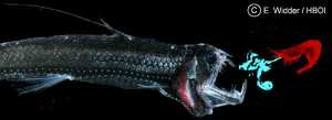
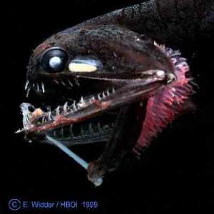
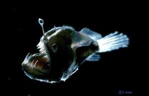
But, did you know bioluminescence is responsible for illuminating the majority of our habitable world? That’s right, the deep sea is the largest area of habitable space on our planet. A large number of species that utilize this adaptation live in that environment. Here are some images of the inhabitants of the deep sea that use bioluminescence:

Deep sea shrimp, Acanthephyra purpurea

Deep sea fish, Photostomias guernei

Blackdevil angler fish, Melanocetus johnsonii

All images (c) NOAA.

Test your knowledge: Social science of the ocean

Here are some more sample questions from the Consortium for Ocean Leadership‘s popular National Ocean Science Bowl. These questions come from the Social Science section.

Good luck!

1.) How often have men descended to the Challenger Deep? a) Once b) Twice c) Three times d) Never

Map showing the location of the Mariana Trench...

Image via Wikipedia

(The Challenger Deep is 36,000 feet deep along the Mariana Trench.)

2.) In 1933, the US tanker Ramapo encountered the highest wind wave ever measured reliably. How tall was this wave? a) 12 meters b) 34 meters c) 42 meters d) 54 meters

3.) Which of the following is NOT an example of human-made structure designed to stabilize the shoreline? a) Breakwater b) Jetty c) Tibia d) Pier

Answers can be found here.