Portolan refers to navigational charts dating back to the Renaissance. They were focused on coastal outlines and included seaports, river openings, shoals and hazards. The distance from one point to another was always included. Latitude and longitude were not features on the maps, neither was interior land. Portolan comes from the Italian adjective “portolana” meaning “related to ports or harbors”.
It’s as easy as A, B, Sea: E for Epipelagic
Epipelagic is the area of the water column extending from the surface of the water down to 700 feet. Since is the only zone that the sunlight can penetrate this is the only zone where plants reside. Consequently, this is where 90% of ocean life hangs out.
The epipelagic zone is also known as the sunlight or euphotic zone.
It’s as easy as A, B, Sea: D for Diaz, Bartholomeu
Bartholomeu Diaz was a Portuguese navigator who was the first person to sail around the Cape of Good Hope. His flotilla of three ships are thought to have rounded the tip of Africa the first week of February in 1488. He was sent by Prince John (eventually King) to explore the west coast of Africa south of fifteen degrees latitude in an effort to understand how Africa and India are linked.
It’s as easy as A, B, Sea: B for Baffin Bay
I love the game Scattegories so I am going to be drawn to learning new words that will help me gain more points.
The Baffin Bay separates Greenland from Canada and is connected to the Atlantic Ocean by the Davis Strait. You won’t be finding any vacation homes along the shores of the Baffin Bay as the surrounding islands are cold and mountainous and the Bay is covered in ice for most of the year.
The Baffin Bay is approximately 700 miles long, varies from 70 to 400 miles in width and ranges from 1,200 to 9,000 feet deep.
A naturalist’s must-see destination: Chesapeake Bay
This is a continuation on the “Where we live” series. The Chesapeake Bay has undergone similar changes to the San Francisco Bay as the population increased along its shores. As the largest estuary in North America (not the longest, which is the Indian River Lagoon in Florida), it is not surprising that the watershed of the Chesapeake Bay flows through six states and covers an area of 64,000 square miles. Flowing from the watershed and into the Bay are over 124,000 miles of rivers and streams!
Due to the relatively shallow average depth of the Bay (at nearly 21 feet) the sun can reach the bottom easily and makes for a productive ecosystem. Just about 40% of the nation’s blue crab commercial blue crab harvest comes from the Chesapeake Bay. Nearly, 300 hundred species call the Bay their home during some part of their life cycle. Birds have come to rely on the diverse community for sustenance while making their way along the Atlantic Flyway.
As I mentioned above, the Bay has undergone changes in recent history. These changes have been rather unfavorable as more and more people flock to the the shores of the Bay, disturbing the natural balance. The Chesapeake Bay Program is an organization leading the way it the restoration efforts and is often seen as the model on how to mitigate the effects of man and maintain a healthy existence of man and nature.
Who owns the oceans?
We all own the oceans … no, wait! No one owns the oceans. Sometimes it is very confusing to answer this question.
Since the third United Nations Convention on the Law of the Sea the jurisdictions of the oceans are known as this:
- 0-3 nautical miles from the coastline of the country is considered a countries’ territorial seas and are subject to the rules of the country. Invading these waters can be seen as attack.
- In the United States 0-12 nautical miles is subject to individual state laws.
- Adjacent to the 12 nautical miles and out to 200 nautical miles is the Exclusive Economic Zone which gives states and/or a countries the “right to explore and exploit, and the responsibility to conserve and manage, the living and non-living resources.”
For more information click here.
What is bioluminescence?
Bioluminescence means light (as in ‘illuminate‘) from life (prefix ‘bio‘).
It is produced by a chemical reaction in many marine or terrestrial organisms. The reaction begins with a chemical called luciferase that catalyzes another chemical, luciferin, to then make oxyluciferin and light.
If you see bioluminescence from a boat it is most often tiny dinoflagellates near the surface of the water that begin this chemical reaction once they’re excited. A boat or a passing porpoise can trigger this excitement. On land we are familiar with bioluminescence in fireflies and a glowing fungus, called foxfire.
But, did you know bioluminescence is responsible for illuminating the majority of our habitable world? That’s right, the deep sea is the largest area of habitable space on our planet. A large number of species that utilize this adaptation live in that environment. Here are some images of the inhabitants of the deep sea that use bioluminescence:
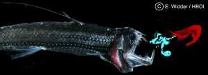 Deep sea shrimp, Acanthephyra purpurea
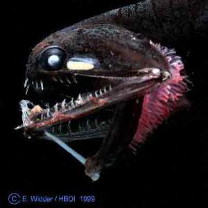 Deep sea fish, Photostomias guernei
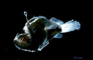 Blackdevil angler fish, Melanocetus johnsonii
All images (c) NOAA.
Test your knowledge: Social science of the ocean
Here are some more sample questions from the Consortium for Ocean Leadership‘s popular National Ocean Science Bowl. These questions come from the Social Science section.
Good luck!
1.) How often have men descended to the Challenger Deep? a) Once b) Twice c) Three times d) Never
(The Challenger Deep is 36,000 feet deep along the Mariana Trench.)
2.) In 1933, the US tanker Ramapo encountered the highest wind wave ever measured reliably. How tall was this wave? a) 12 meters b) 34 meters c) 42 meters d) 54 meters
3.) Which of the following is NOT an example of human-made structure designed to stabilize the shoreline? a) Breakwater b) Jetty c) Tibia d) Pier
Answers can be found here.
What is the difference between a swamp and a marsh?
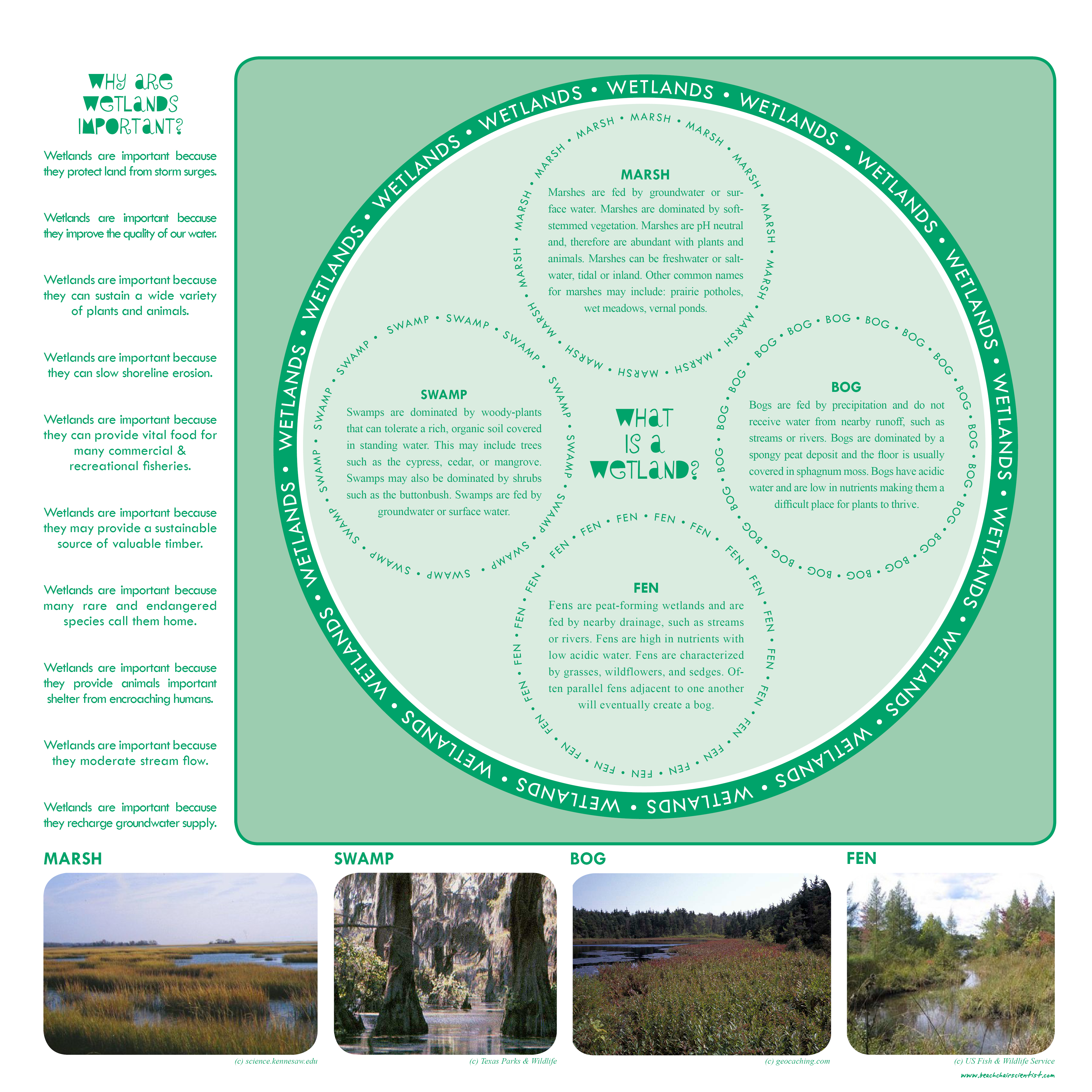
Swamps and marshes are easily interchanged as they are both areas of vegetation that are susceptible to flooding. In North America they are defined a little differently (check out this BCS post for a quick lesson in wetland ecology – image below). A swamp is a place where the plants that make up the area covered in water are primarily woody plants or trees. Woody plants would be mangroves or cypress trees. A marsh, on the other hand, is defined as having no woody plants. The non-woody plants would be saltmarsh grasses, reeds, or sedges. Also, marshes are typically not as deep as swamps.
Both swamps and marshes are great place for wildlife. With so many plants in the water, fish use marshes and swamps as a nursery ground. The plants are a great place to hide their eggs and are a hiding spots for juvenile fish to hide from predators.
Swamps and marshes can be either freshwater, saltwater, or a mixture of both. Some marshes or swamps are found in bodies of water that are a mixture of freshwater and saltwater, known as an estuary.
Image (c) top – en.tourduvalat.org; bottom – www.tpwd.state.tx.us
Do you have a question that needs to be answered? Just e-mail us at info@beachchairscientist.com.
Test your knowledge: National Ocean Science Bowl sample question
The National Ocean Science Bowl is a high school challenge program run by the Consortium for Ocean Leadership and is dedicated to preparing the next generation of scientists, teachers, policy makers, environmental advocates and concerned citizens to “continue the exploration and develop strategies for managing the oceans’ resources.”
Here is a sample question taken from their resources page to test your knowledge:
This national marine sanctuary, sometimes called The Galapagos of California, is home to kelp forests, sea lions and blue whales. a) Stellwagen Banks b) Channel Islands c) Monterrey Bay d) Olympic Coast
The answer is the Channel Islands, a set of five islands off the coast of California.
Image (c) oceanleadership.org.






What people are saying …