What makes each ocean unique?

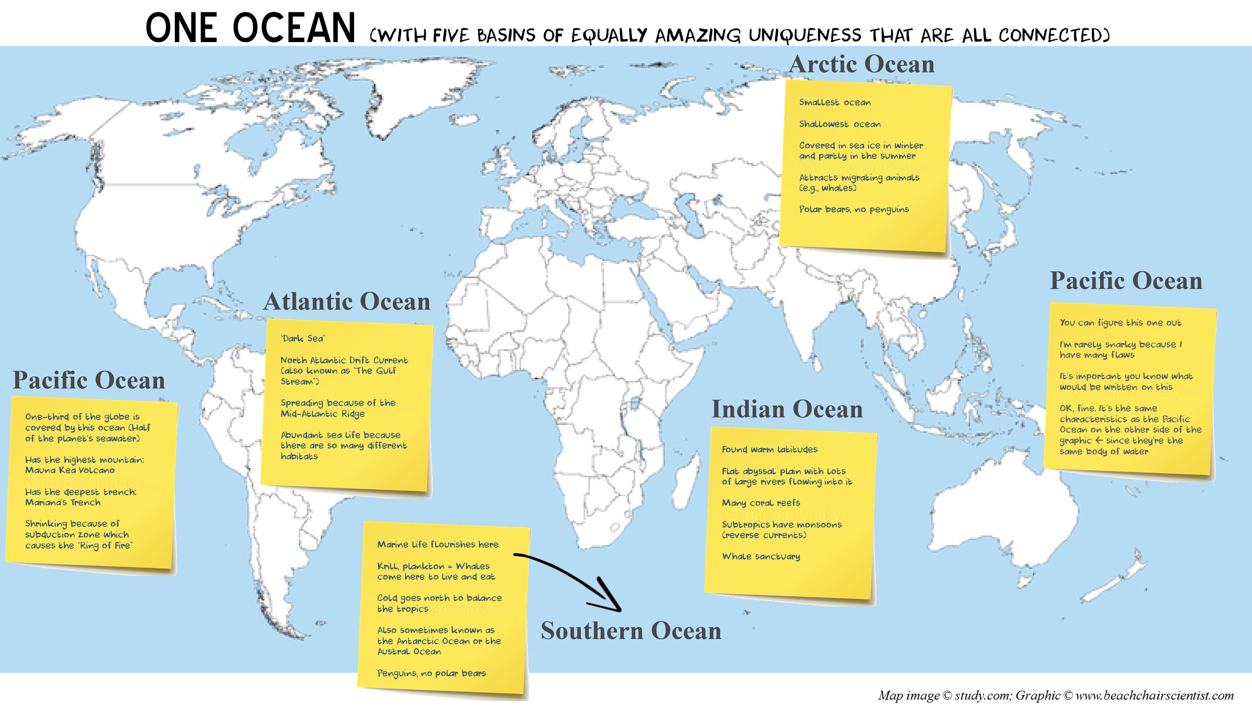
Well, it’s finally happened. My almost seven-year old is bringing on the thought-provoking questions. We talk a lot about how what we do in our house will affect our watershed and that in turn (collectively) affects the world. Well, I was snagged the other day when I said, “Well, the river goes to the lake and leads to another lake and river and then to the ocean. And, it’s the only ocean we have so we need to take care of it.” What I heard next was, “Mom, if it goes into the Atlantic Ocean isn’t there also the Pacific? Isn’t that two oceans?” She’s not alone in the confusion as I’ve had students not sure how the oceans are connected (Giant Conveyor Belt of currents!) and why do we give them all different names.

I laid it out like this: There is only one ocean, but each area of the world has a section (i.e., basin) of the ocean that has specific properties based on temperature and what type of land it is near. For instance, the Pacific Ocean is huge, has rocky shorelines, and lots of volcanoes and islands because it’s surrounded by the “Ring of Fire.” I explained that the Indian Ocean is pretty flat almost like the Gulf of Mexico because lots of rivers flow gently into it.

Here’s a quick graphic I fancied up to share on some major characteristics of each ocean basin. Click on it and then travel around to each one! I like to keep it simple so if you feel like there’s something that needs additional emphasis, please feel free to share so I can add it!


The flight of swallows

That’s a great title for a song if someone wants to use it. In any event, have you ever been to the beach or walking along the marsh and felt the gloom and doom of darkness approach even though it’s a bright and sunny day? Have you ever looked up into the sky to witness the emergence of a feathered tornado? What you’re watching is the flight of the swallows – which can be up to several thousand birds approaching in one flight!

These no-more-than-14-centimeter-in-length birds are commonly seen swarming along the mid-Atlantic coast in September, the tail end of their breeding season. However, they are found throughout central and northern North America during their entire breeding season from May to September. These very social birds winter in Florida and the Caribbean. They’re rarely seen on land and spend the majority of their life in trees, maybe coming down to earth just to graze their wings along the surface of a body of water for a quick bath.

Why are they found along the mid-Atlantic coast in September? Well, they congregate in large flocks to roost among groves of small trees and cattails away threats (e.g., lots of people). They also prefer to make the nest for their eggs in the holes of dead trees away from threats. Male and female swallows are very territorial when it comes to their nest and will stand guard even from approaching fellow swallows.

Swallows produce one brood per year, averaging 5 eggs. These birds prove it takes a village as they make a nest for their eggs using the feathers of other birds to keep the eggs warm. The eggs typically hatch in about two weeks and are able to fly from the nest after three weeks. In one year the young swallow will be mature enough to breed!

And, in case you’re not familiar with the phenomenon – check out this well done amateur video I found on YouTube of a swarm of swallows (set to classical music no less!). It’s quite to spectacular sight.

Other great bird resources:


What are the world’s largest oceans and seas?

Great question! Here is a quick break down of the world’s largest oceans and seas using the size information found in the descriptions from The World’s Biggest Oceans & Seas by Our Amazing Planet.

If you have another question please don’t hesitate to find me on Twitter using @bcsanswers or just email info@beachchairscientist.com. Have a great beachcombing weekend!

Also, here is a map to reference each body of water listed above.

Sea level rise is settled fact

“Some scientific conclusions have been so thoroughly examined and tested, and supported by so many independent observations and results, that their likelihood of being found wrong is vanishingly small. Such conclusions are then regarded as settled facts. This is the case for the conclusions that the Earth system is warming and that much of this warming is very likely due to human activities … strong evidence on climate change underscores the need for actions to reduce emissions and begin adapting to impacts.”
America’s Climate Choices, U.S. National Academy of Science, National Research Council, 2011

Climate change is taking place and poses considerable risks for us. Among these risks are the detrimental impacts related to sea level rise. And for those of us along the Atlantic coast the impacts may hit sooner rather than later. According to a recently published study by researchers with the U.S. Geological Survey (USGS), sea levels from Cape Hatteras to Cape Cod (a 620-mile Atlantic coast ‘hot spot’) are rising more rapidly than anywhere on Earth – at the speed of three to four times faster than the global average. The study found that since 1990, sea levels have risen approximately 0.08 inches (2 millimeters) to approximately 0.14 inches (3.7 millimeters) a year along the ‘Atlantic coast hot spot’ while the global average for the same time period was 0.6 millimeters to 1 millimeter per year.

The study also noted that sea levels will rise 9 inches by 2030, 18 inches by 2050, and four-and-a-half feet by 2100 globally. Experts at the USGS, as well as other scientists, agree that this increase is due to climate change and other factors. However, according to Asbury Sallenger, the USGS oceanographer who led the study, “sea levels will rise an additional 8 inches to 11 inches in the Atlantic coast hot spot”. Just last week the National Research Council noted that sea levels along California will rise one foot in the next twenty years. Sinking land masses along the California coast and climate change was said to be the cause of that sea level rise.

But what is the cause of the additional increase of 8 inches to 11 inches in sea level rise along the ‘Atlantic coast hot spot’? This can be attributed to the slowing of Atlantic currents by the influx of freshwater into the salty Atlantic Ocean. Melting glaciers from the Greenland Ice Sheet send freshwater into a conveyor belt current (known as the Atlantic Meridional Overturning Circulation) which cause variations in temperature, salinity, and the speed of currents all of which affect sea level rise as warming oceans expand.

Ultimately, this study proves that sea levels have risen since 1990 regardless of the cause. It also provides a call for communities along the Atlantic coast to start planning for sea level rise as many densely-populated cities (Boston, Providence, New York City, Philadelphia, Baltimore, and Norfolk-Virginia Beach) can be found along the ‘Atlantic coast hot spot’ and could see an increase in damages from storm surge.

Here is a list of 50 Things to Reduce Climate Change that will help reduce emissions that attribute to sea level rise. After all, it is not just the impacts from sea level rise, but our health, rainfall, agricultural crop yield, energy supply, as well as other beautiful natural ecosystems that are all affected by climate change.

USGS Researchers used long-term data from tidal gauges along the coast and computer simulations designed at calculating the effects of climate change for their study. The study was published in the journal Nature Climate Change.

 Resources:

How much salt is in the ocean? Revisited

In late 2008, I wrote a very simple post explaining ‘salinity’ and the overall general amount of salt in the ocean. Now, with new data being collected by NASA (in a joint mission with Argentina) using the Aquarius instrument aboard a satellite, Satélite de Aplicaciones Científicas, we are able to more completely understand “How salty is the sea?” The satellite measures  the “brightness temperature” of the top centimeter layer of ocean waters.

June 10, 2012 marked was the one year anniversary this satellite has been in orbit. In the past year many finding have been confirmed using three sensors to collect approximately 3.6 million measurements (300,000 measurements per month)! For instance, 1) the Atlantic ocean is saltier than the Pacific ocean, 2) long rivers are responsible for massive plumes of freshwater that extend far into the sea (e.g., Mississippi River carry lots of freshwater into the Gulf of Mexico, the Kissimmee River, Lake Okeechobee, and the Everglades flowing into the Florida Keys region), and 3) rainfall along the equator’s rainforest create a significantly more diluted ocean than we once previously had envisioned.

Trivia question: Can anyone tell me the what you call the body of water where freshwater from rivers mix with the salty ocean water?

Check out the maps of the Saltiness of the Earth’s Ocean from Our Amazing Planet.

A naturalist’s must-see destination: Cape May County (and, the rest of south Jersey)

Earlier this year I was happy to see that the federal government had awarded New Jersey a $1 million grant to protect the ecologically sensitive wetlands in Cape May County (“Where Nature Smiles for 30 Miles” and where my hometown is located). The New Jersey Department of Environmental Protection (DEP) will use the money to purchase 140 acres to add to the existing 17,000-acre Cape May Wetlands Wildlife Management Area. These wetlands are not only where I fell in love with the natural world, but are also home to many species of migratory birds and act as a nursery for many commercially important species of fish that spawn in the estuaries.

So with a combination of my pride in the DEP’s award and my feelings that an ‘ode to home’ in the Where We Live series is long overdue, I decided to take the time to compile a list of “10 unique and interesting natural history or maritime features of south Jersey”. I am sure there are plenty more out there, so please feel free to comment below or send me an email at info@beachchairscientist.com if you have any additional comments or questions.

1. South Jersey sits to the east of the Delaware Bay. The Delaware Bay boasts the second-highest concentration of shorebirds in North America (second to Quivira, Kansas which is mid-point in the United States). The Bay is mid-point in travel for many birds that travel from the warm weather of South America up to the Arctic. The Bay is also a perfect wintering habitat for many species of songbirds and waterfowl.

2. The world’s largest population of Atlantic horseshoe crabs (Limulus polyphemus) spawn in Delaware Bay.

3. At the entrance of the Delaware Bay is the Cape May Lighthouse, built in 1859, which documents the beginning of Cape May County’s nautical history. There is also the Hereford Inlet Lighthouse, built in 1874, on the Atlantic Ocean side of the Cape May County peninsula in North Wildwood. Speaking of Cape May, the famous Cape May diamonds people have been looking for since the 1880’s are actually quartz crystals that wash up as smooth rock.

4. At 3800 Boardwalk Mall in Wildwood you can see the 43rd Wyland Whaling Wall, “Humpbacks off the Jersey Coast” (pictured right). Wyland is known as “one of America’s most unique creative influences, and a leading advocate for marine resource conservation”.

5. The A.J. Meerwald, New Jersey’s official Tall Ship, began life as a sailing schooner built for oystering,  but was commandeered during World War II to serve as a fireboat on the Delaware Bay.

6. The Stone Harbor Point is one of the few parcels of New Jersey’s coast that has not been stabilized (86% of the shoreline has been stabilized) leaving a remarkable wide open space that has been shaped (and reshaped) by waves and tides for centuries. It also has one of the last thickets of bayberry left on New Jersey’s coast.

7. The Marine Mammal Stranding Center in Brigantine has the impressive achievement of responding to over 3,900 strandings of whales, dolphins, seals, and sea turtles (all, of course, done with a permit and authorization from the state and federal governments).

8. In south Jersey you’ll also find the Pine Barrens, a distinctive natural area spanning over  1 million acres of the Outer Coastal Plain (pictured left) in southern and central New Jersey. Dr. Witmer Stone, an early New Jersey natural scientist described the area as “always sandy and thickly covered with more or less scrubby vegetation, interspersed with swamps and infested by hordes of mosquitoes”. This area is particularly prone to fires and some species, such as the rare pygmy Pitch Pine, have become adapted to the fires and count on the fires to reproduce. The sandy soil of the Pine Barrens is sometimes referred to as sugar sand.

9. Blueberries were officially named the state fruit in 2004. New Jersey produces the second most blueberries in the world (Maine is first). Hammonton is considered the “Blueberry Capital of the World”.

10. After the federal government designated the Outer Coastal Plain as an American Vinticultureal Area, south Jersey started up on the wine trend! Now south Jersey has more than 20 fully functioning wineries and vineyards.

As Jacques Cousteau said, “People protect what they love“. I am sure you can tell from this blog that I do love the ocean. This love no doubt came from growing up in south Jersey and spending time everyday at the beach or the nearby Bay.  Here’s a poem I wrote (almost 12 years ago) about the area. I hope you’re inspired to learn about the natural history of your own area – especially on this upcoming Earth Day weekend.

Cheers!

April is National Frog Month

Yes, that is correct – April is National Frog Month. However, this is not a post about the amphibian, but is all about the frogfish! Contrary to popular belief, it’s easy being green if you’re a frogfish. First of all, you can change colors from green to black, or red, or orange, or yellow, or brown, or white, or purple, or even blue! These colors help the frogfish mimic corals, sponges, algaes, or even rocks. Often a trusting fish become prey all too easily as they go to hide in the ‘coral’ or ‘rock’ only to then get eaten by the frogfish that has transformed . Frogfish gobble up their prey in 6 milliseconds. Frogfish actually have the fastest mouth in the sea. Their mouth is able to expand 12 times its size and they can easily eat prey 25 percent longer. They’re opportunistic and eat whenever possible. They tend to feast on smaller fish, crustaceans, or even other frogfish!

Another amazing mechanism of the frogfish is an antenna that dangles from their head. They’ll mimic the actions of a smaller animal (e.g., a worm or shrimp) with this antenna so that their own prey will swim right up to them. Don’t worry though, the lure will regenerate if eaten.

Frogfish do not have a swim bladder, but do have modified pectoral fins enabling them to ‘walk’ along the seafloor. See the video below to see this in action.

Frogfish live in the tropical and subtropical areas in the Atlantic, Indian, and Pacific Oceans.

It is the original footage from these hairy frog fish walking on the sand was made by Daan van Wijk in Indonesia. These scenes are from the movie Impressionesia”.

Test your knowledge: Alphabet soup

See if you can guess what these marine-related acronyms stand for with the clues provided.

AFS: Organization of fisheries professionals. Seattle is hosting their conference this year.
BCS: A nice and funny blogger who enjoys making marine science entertaining (and it has nothing to do with college football).
CBP: A regional partnership that has led and directed the restoration of one the most diverse estuaries since 1983.
ICCAT: An inter-governmental fishery organization responsible for the conservation of tunas (and tuna-like species) in the Atlantic Ocean and its adjacent seas.
MSP: Concept that allows multiple users of the oceans to coordinate (or plan) decisions for a sustainable future.
NEPA: Signed into law on January 1, 1970 this Act set out to “assure that all branches of government give proper consideration to the environment prior to undertaking any major federal action that could significantly affect the environment.”
NOAA: No, no, no … It’s not National Offshore Aquaculture Act of 2007 … it’s the other one. This federal agency oversees the oceans. They also oversee the atmosphere as well (i.e., hurricanes, climate, etc).
PFD: Please bring one of these for every person on your boat this summer.
SAV: Beds of this are important habitat for many species that use estuaries as nursery grounds.
VIMS: College that runs (through SeaGrant) BRIDGE (teacher-approved marine resources).

Test your knowledge: National Ocean Science Bowl biology

Here are some more sample questions from the Consortium for Ocean Leadership‘s popular National Ocean Science Bowl (NOSB). These questions come from the Biology section.

Good luck!

1) Northern elephant seals come ashore during the spring and summer to do what? a) Mate b) Eat c) Give birth d) Shed their fur

2) The habitat of blue whales, tunas and swordfishes is best described as: a) Benthic b) Littoral c) Estuarine d) Pelagic

3) Intensive aquaculture of which of the following organisms has contributed to loss of mangroves around the world? a) Tilapia b) Cod c) Salmon d) Shrimp

4) Lophelia (LO-fee-lee-ua) coral reefs in the North Atlantic are being primarily damaged by: a) Pfiesteria b) Poisoning c) Rising temperatures d) Trawling

Jellywatch

It is gearing up for summertime so if you see a jellyfish on the beach, report it here. They actually want to hear about all your fun and exciting ocean finds. And best of all there is no registration – so get to it!